

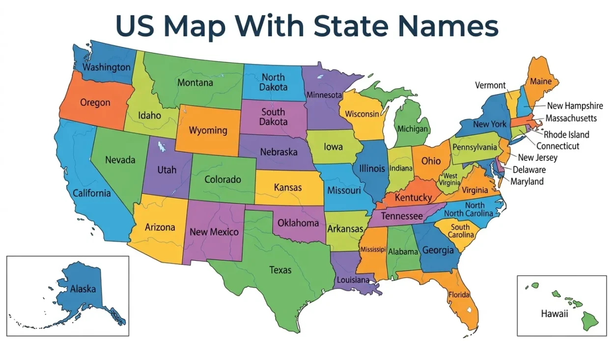
If you are looking for a US map with state names, you probably want a simple way to see, learn, or remember all 50 U.S. states. A labeled map makes geography much easier because you can quickly match each state with its location, neighbors, and region.
A blank map can be useful for testing your knowledge, but a map with state names is better when you are learning for the first time.
Students can use it for school projects, teachers can use it in classrooms, and travelers can use it to understand where different states are located.
The United States is made up of 50 states, and each state has its own location, name, shape, and identity. From California on the West Coast to Maine in the Northeast, a labeled map helps you see the whole country at a glance.
In this guide, you will learn about the US map with state names, the 50 states, U.S. regions, state abbreviations, and easy ways to remember their locations.
🗺️ US Map With State Names: Quick Overview
A labeled U.S. map shows the names of the states directly on the map. It helps you connect a state’s name with its position instead of trying to memorize a long list.
The map can be especially helpful when learning the difference between neighboring states or studying U.S. geography.
The 50 U.S. States
| State | Abbreviation | Capital |
| Alabama | AL | Montgomery |
| Alaska | AK | Juneau |
| Arizona | AZ | Phoenix |
| Arkansas | AR | Little Rock |
| California | CA | Sacramento |
| Colorado | CO | Denver |
| Connecticut | CT | Hartford |
| Delaware | DE | Dover |
| Florida | FL | Tallahassee |
| Georgia | GA | Atlanta |
| Hawaii | HI | Honolulu |
| Idaho | ID | Boise |
| Illinois | IL | Springfield |
| Indiana | IN | Indianapolis |
| Iowa | IA | Des Moines |
| Kansas | KS | Topeka |
| Kentucky | KY | Frankfort |
| Louisiana | LA | Baton Rouge |
| Maine | ME | Augusta |
| Maryland | MD | Annapolis |
| Massachusetts | MA | Boston |
| Michigan | MI | Lansing |
| Minnesota | MN | Saint Paul |
| Mississippi | MS | Jackson |
| Missouri | MO | Jefferson City |
| Montana | MT | Helena |
| Nebraska | NE | Lincoln |
| Nevada | NV | Carson City |
| New Hampshire | NH | Concord |
| New Jersey | NJ | Trenton |
| New Mexico | NM | Santa Fe |
| New York | NY | Albany |
| North Carolina | NC | Raleigh |
| North Dakota | ND | Bismarck |
| Ohio | OH | Columbus |
| Oklahoma | OK | Oklahoma City |
| Oregon | OR | Salem |
| Pennsylvania | PA | Harrisburg |
| Rhode Island | RI | Providence |
| South Carolina | SC | Columbia |
| South Dakota | SD | Pierre |
| Tennessee | TN | Nashville |
| Texas | TX | Austin |
| Utah | UT | Salt Lake City |
| Vermont | VT | Montpelier |
| Virginia | VA | Richmond |
| Washington | WA | Olympia |
| West Virginia | WV | Charleston |
| Wisconsin | WI | Madison |
| Wyoming | WY | Cheyenne |
🌎 Northeast States
The Northeast is one of the most well-known U.S. regions. It includes states along the Atlantic coast and several states farther inland.
A US map with state names makes this region easier to study because many Northeast states are small and located close together.
- Maine
Meaning: The northeasternmost state in the contiguous United States. - New Hampshire
Meaning: A small New England state located west of Maine. - Vermont
Meaning: A landlocked New England state known for its mountains and forests. - Massachusetts
Meaning: A coastal New England state home to Boston. - Rhode Island
Meaning: The smallest U.S. state by area. - Connecticut
Meaning: A small New England state between New York and Rhode Island. - New York
Meaning: A large northeastern state famous for New York City. - New Jersey
Meaning: A coastal state located between New York and Pennsylvania. - Pennsylvania
Meaning: A large northeastern state with Philadelphia and Pittsburgh. - Delaware
Meaning: A small Mid-Atlantic state located along the Atlantic coast.
🏙️ Midwest States
The Midwest sits near the center and northern part of the United States. It includes major farming areas, large cities, lakes, and wide plains.
When studying a labeled U.S. map, look for the Great Lakes and the states around them to understand the region.
- Ohio
Meaning: A Great Lakes state east of Indiana. - Michigan
Meaning: A state surrounded by the Great Lakes and shaped by two main peninsulas. - Indiana
Meaning: A Midwestern state located between Illinois and Ohio. - Illinois
Meaning: A Midwestern state known for Chicago. - Wisconsin
Meaning: A northern Midwestern state bordering Lake Michigan and Lake Superior. - Minnesota
Meaning: A northern state famous for its many lakes. - Iowa
Meaning: A central Midwestern state known for agriculture. - Missouri
Meaning: A state located near the geographic center of the country. - Kansas
Meaning: A Great Plains state known for wide-open farmland. - Nebraska
Meaning: A Great Plains state located between South Dakota and Kansas.
🌵 Southern States
The South covers a large area of the United States. It includes coastal states, inland states, and states along the Gulf of Mexico.
A labeled map helps you see how these states connect from the Atlantic Coast to Texas.
- Texas
Meaning: A very large southern state located along the U.S.-Mexico border. - Florida
Meaning: A southeastern peninsula surrounded by the Atlantic Ocean and Gulf of Mexico. - Georgia
Meaning: A southeastern state located north of Florida. - Alabama
Meaning: A southeastern state with a short Gulf Coast. - Mississippi
Meaning: A southern state located along the Mississippi River. - Louisiana
Meaning: A Gulf Coast state known for New Orleans and its unique culture. - Arkansas
Meaning: An inland southern state located west of the Mississippi River. - Tennessee
Meaning: A long east-west state known for Nashville and Memphis. - South Carolina
Meaning: A southeastern coastal state known for beaches and historic cities. - North Carolina
Meaning: A southeastern state with mountains, forests, and an Atlantic coastline.
🏔️ Western States
The West covers a huge part of the United States. It includes deserts, mountains, forests, beaches, and some of the country’s largest states.
On a US map with state names, the Western states are easy to spot because they cover much of the country’s western half.
- California
Meaning: A large Pacific Coast state known for Los Angeles and San Francisco. - Oregon
Meaning: A Pacific Northwest state located north of California. - Washington
Meaning: The northernmost Pacific Coast state in the contiguous U.S. - Nevada
Meaning: A western desert state known for Las Vegas. - Arizona
Meaning: A southwestern state famous for the Grand Canyon. - Utah
Meaning: A western state known for mountains, deserts, and national parks. - Idaho
Meaning: A northwestern state known for mountains, forests, and farmland. - Montana
Meaning: A large northwestern state known for mountains and open landscapes. - Wyoming
Meaning: A western state home to Yellowstone and Grand Teton areas. - Colorado
Meaning: A Rocky Mountain state known for high mountains and outdoor recreation.
🧭 Southwest States
The Southwest has a distinct geography and culture. It includes deserts, mountains, canyons, and states near the Mexican border.
These states are easy to identify on a labeled map once you learn their basic positions.
- Arizona
Meaning: A southwestern state famous for the Grand Canyon. - New Mexico
Meaning: A southwestern state known for desert landscapes and Santa Fe. - Texas
Meaning: A huge state covering much of the southern-central United States. - Oklahoma
Meaning: A state north of Texas and west of Arkansas. - Nevada
Meaning: A western desert state located near California and Arizona. - Utah
Meaning: A mountain and desert state east of Nevada. - Colorado
Meaning: A Rocky Mountain state north of New Mexico. - California
Meaning: A Pacific Coast state bordering Arizona and Nevada. - Kansas
Meaning: A Great Plains state located northeast of Oklahoma. - Arkansas
Meaning: An eastern neighbor of Oklahoma and Texas.
❄️ Mountain States
The Mountain region contains many states with high elevations and dramatic landscapes. The Rocky Mountains are an important geographic feature in this part of the country.
A map with state names makes it easier to see how these states form a broad group across the West.
- Montana
Meaning: A large northern Mountain state. - Idaho
Meaning: A northwestern Mountain state with many forests and mountains. - Wyoming
Meaning: A Mountain state located south of Montana. - Colorado
Meaning: A Rocky Mountain state famous for its high peaks. - Utah
Meaning: A Mountain West state with deserts and colorful rock formations. - Nevada
Meaning: A western state dominated by desert and mountain landscapes. - Arizona
Meaning: A southwestern state with deserts and deep canyons. - New Mexico
Meaning: A southwestern Mountain state with high deserts. - Oregon
Meaning: A Pacific Northwest state with mountains and forests. - Washington
Meaning: A Pacific Northwest state with mountain ranges and coastal areas.
🌊 Pacific Coast States
The Pacific Coast states sit along the western edge of the United States. They are easy to remember because they touch the Pacific Ocean.
Looking at these states on a US map with state names is a great starting point for learning U.S. geography.
- Washington
Meaning: The northernmost Pacific Coast state in the contiguous U.S. - Oregon
Meaning: A coastal state between Washington and California. - California
Meaning: The large southern Pacific Coast state. - Alaska
Meaning: The largest U.S. state, located far northwest of the contiguous states. - Hawaii
Meaning: An island state located in the central Pacific Ocean. - San Francisco
Meaning: A famous California city, not a state. - Los Angeles
Meaning: A major California city, not a state. - Seattle
Meaning: A major Washington city, not a state. - Honolulu
Meaning: The capital and largest city of Hawaii. - Anchorage
Meaning: Alaska’s largest city, though Juneau is its capital.
🏝️ Alaska and Hawaii
Alaska and Hawaii are different from the other 48 states because they are not part of the contiguous United States. They are often shown separately in a small box or inset on U.S. maps.
Understanding their locations can help prevent confusion when reading a full map.
- Alaska
Meaning: The largest U.S. state by area. - Hawaii
Meaning: The only U.S. state made entirely of islands. - Juneau
Meaning: The capital of Alaska. - Honolulu
Meaning: The capital of Hawaii. - Aleutian Islands
Meaning: A chain of islands extending westward from Alaska. - Hawaiian Islands
Meaning: The island chain that forms the state of Hawaii. - Anchorage
Meaning: Alaska’s largest city. - Big Island
Meaning: The largest island in Hawaii by area. - Pacific Ocean
Meaning: The ocean surrounding Hawaii and bordering Alaska’s western side. - Arctic Ocean
Meaning: The ocean north of Alaska.
📚 US Map With State Names for Students
A labeled map is one of the easiest tools for students learning U.S. geography. Instead of memorizing 50 names in random order, students can group states by region.
Start with the large and easy-to-recognize states. Then learn the smaller states around them.
Here are simple study tips:
- Learn five to ten states at a time.
- Start with the West Coast.
- Learn the Great Lakes states together.
- Study the Northeast separately.
- Use state abbreviations as memory clues.
- Practice with a blank map after learning the labeled map.
- Learn state capitals after learning state locations.
- Quiz yourself without looking at the map.
For example, remember California, Oregon, and Washington as a simple north-to-south coastal group. Then learn the states that sit directly east of them.
🧠 Easy Ways to Memorize All 50 States
Learning all 50 states can seem hard at first. The good news is that you do not need to memorize everything in one sitting.
Break the country into small groups. A US map with state names can help you build a mental picture of each group.
1. Learn by Region
Start with Northeast, Midwest, South, and West. This gives each state a place in your memory.
2. Learn by Neighbors
Pick one state and learn the states around it. For example, learn which states border Texas.
3. Use Map Shapes
Some states have shapes that are easy to recognize. Florida, Texas, California, and Michigan are good examples.
4. Practice With a Blank Map
Once you know the labeled map, switch to a blank map. Try writing each state name in the correct place.
5. Repeat Often
Short practice sessions work well. Spend five or ten minutes reviewing the map each day.
📝 US State Abbreviations
State abbreviations are useful when reading addresses, maps, charts, and travel information. Each state has a standard two-letter abbreviation.
Some common examples include:
- California : CA
- Texas : TX
- Florida : FL
- New York : NY
- Washington : WA
- Arizona : AZ
- Colorado : CO
- Illinois : IL
- Michigan : MI
- Pennsylvania : PA
- Ohio : OH
- Virginia : VA
- Georgia : GA
- Alaska : AK
- Hawaii : HI
Learning abbreviations alongside a labeled map can make state names easier to recognize.
🔎 US Map With State Names vs. Blank US Map
Both map types are useful, but they serve different purposes. A labeled map helps you learn, while a blank map helps you test what you know.
| Map Type | Best Use |
| Labeled U.S. Map | Learning state locations |
| Blank U.S. Map | Testing geography knowledge |
| Map With Capitals | Learning state capitals |
| Political Map | Studying state borders |
| Physical Map | Studying mountains, rivers, and landforms |
| Regional Map | Learning groups of states |
If you are new to U.S. geography, start with the US map with state names. Once you feel comfortable, move to a blank map.
🎓 Why Use a Labeled U.S. Map?
A labeled map is useful in many situations. It is not only for schoolwork.
Teachers can use it for geography lessons. Parents can use it to help children learn the states. Travelers can use it to understand where destinations are located.
It can also help with:
- Geography homework
- Classroom activities
- State quizzes
- U.S. history lessons
- Travel planning
- Learning state capitals
- Memorizing state abbreviations
- School presentations
- Geography games
- General knowledge
The biggest benefit is simple: you can see where each state is instead of only reading its name.
🗺️ How to Read a US Map With State Names
Reading a U.S. map becomes easier when you know what to look for. First, find the four main directions: north, south, east, and west.
Then identify major geographic landmarks, such as the Atlantic Ocean, Pacific Ocean, Gulf of Mexico, Great Lakes, and Rocky Mountains.
Next, find large states such as Texas, California, Alaska, and Montana. These can act as useful reference points.
From there, identify neighboring states. Slowly, you can build a mental picture of the entire country.
Remember that Alaska and Hawaii are normally displayed separately from the main continental map because of their distance from the other states.
⭐ Fun Facts About the 50 States
The United States has many interesting geographic facts that make map learning more fun.
- Alaska is the largest state by area.
- Rhode Island is the smallest state by area.
- Hawaii is the only U.S. state made entirely of islands.
- Texas is the second-largest state by area.
- California is the most populous state.
- Maine is the easternmost state of the contiguous U.S. by geographic longitude.
- Florida is the southernmost U.S. state in the contiguous states.
- Michigan has two major peninsulas.
- Colorado is known for its Rocky Mountain landscapes.
- Arizona is home to the Grand Canyon.
These facts can give you extra memory clues when studying a map.
❓FAQs:
How many states are on a US map?
There are 50 states in the United States. A standard U.S. map with state names labels all 50 states.
What are the 50 states of the USA?
The 50 states include California, Texas, Florida, New York, Alaska, Hawaii, and 44 other states. They are spread across several U.S. regions.
Which states are not part of the contiguous United States?
Alaska and Hawaii are not part of the contiguous 48 states. They are commonly shown separately on U.S. maps.
What is the smallest U.S. state?
Rhode Island is the smallest U.S. state by area.
What is the largest U.S. state?
Alaska is the largest U.S. state by area.
Why is a labeled U.S. map useful?
A labeled map helps you connect each state name with its location. It is useful for students, teachers, travelers, and anyone learning geography.
How can I memorize all 50 states?
Learn the states by region and practice with a labeled map first. Then use a blank map to test your memory.
🏁 Conclusion:
A US map with state names is a simple but powerful tool for learning American geography. It lets you see all 50 states, understand their locations, and notice which states share borders.
You can study the country by region, learn state abbreviations, memorize capitals, or practice with a blank map. Start with a few states and slowly build your knowledge.
If you are a student preparing for a geography quiz, a teacher creating a classroom lesson, or simply someone who wants to know the United States better, a labeled map can make learning much easier.
Pick your favorite way to study, open a US map with state names, and start exploring all 50 states today!